


“Where observation is concerned, chance favors only the prepared mind.”
–Louis Pasteur
• Topographic Services
Modern Landfill Topography Products (ML-Topo) will change the way you look at your landfill…
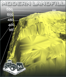
 Current Topographic Maps (Active Areas)
Super-accurate maps showing topography of active areas of your landfill.
- Indication of Waste Placement Areas
- Indication of Airspace Consumption Rate
- Contours in 2-foot Intervals
- Minimum 11×17 Color Drawings in Printable Electronic Format
Airspace Consumption Reports
Learn how much airspace you use at your landfill each week, month, and year…
- Total Airspace Consumed and Consumption Rate
- Analysis of Individual Waste Placement Areas (if >1)
- Lift & Cell Completion Dates
- Estimated Date of Airspace Exhaustion
- Milestone Dates for New Airspace Construction
Annual Report Activities
Information you will need to complete your annual MSW Report
- Current Topography of Entire Landfill Permitted Area
- Annual Airspace Consumption
- Airspace Reclaimed through Settlement
- Total Airspace and Years Remaining
- Location of Remaining Usable Airspace
Grade Control Staking/Flagging
In-the-field indicators of specific grade control features and transitions
- Toe Lines & Daylight Lines
- ELR Infrastructure Boundaries & Alignments
- Other items, as needed
Topography Status/Progress Reports
Evaluation of topography-related performance indicators at your landfill
- Daily & Intermediate Cover Evaluation
- Grade Control Evaluation
- Erosion Control Evaluation
- Leachate Spring Evaluation
- Miscellaneous Observations
Current Topographic Maps (Full Landfill)
This area should contain a brief description of the service title, then use the space below to highlight the service details.